


Snow may fall in parts of mainland Portugal over the coming days as a weather system known as the Goretti depression moves across the country, bringing rain, strong winds and colder temperatures. Meteorologists say snowfall is most likely at higher elevations, particularly in mountainous regions, between today and 9 January.
According to weather specialists, the Goretti depression is expected to introduce a mass of colder air over the Iberian Peninsula, interacting with moist Atlantic conditions. This combination is forecast to produce widespread rainfall across much of the country, with snow falling at altitude where temperatures drop sufficiently.
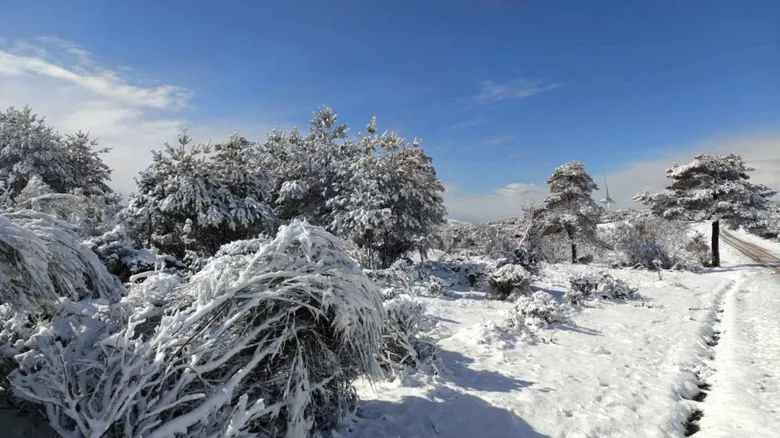
The most likely area to see snowfall is the Serra da Estrela mountain range, Portugal’s highest region, where winter snow is not unusual but remains closely watched due to its impact on transport, tourism and local communities. Snow may also appear on other high points in the north and centre of the country if temperatures fall as predicted.
Forecasters say snow levels are expected to fluctuate depending on the intensity of precipitation and overnight cooling. During heavier rainfall, snow may be confined to the highest peaks, while clearer intervals and colder air could allow snowfall to descend to lower elevations. Accumulation is expected to be limited to mountainous areas, with no indication of snow affecting lowland cities.
Rainfall associated with the Goretti system is forecast to be persistent in several regions, particularly in the north and central interior. While the rain will help replenish water reserves after recent dry periods, it could also lead to localised flooding, especially in areas with saturated soil or poor drainage.
Winds are also expected to strengthen as the depression passes, particularly along the coast and in elevated terrain. Gusty conditions could combine with snow and rain to create difficult driving conditions in mountain passes, prompting authorities to urge caution for anyone planning to travel in affected regions.
Temperatures are forecast to fall noticeably, especially at night. Inland areas could experience near freezing conditions at higher altitudes, increasing the likelihood of frost and icy roads. Coastal areas will remain milder but cooler than average for early January.
Weather experts note that winter systems like the Goretti depression are not unusual at this time of year, but their impact varies depending on how cold air masses interact with Atlantic moisture. This event appears more likely to bring a mix of rain and snow rather than a widespread snowstorm.
Local councils and civil protection authorities are monitoring the situation, particularly in mountainous zones where snowfall can disrupt transport and isolate communities. Road users are advised to check conditions before travelling and to carry appropriate equipment if heading to higher elevations.
For many residents and visitors, snowfall in Portugal’s mountains is seen as a seasonal highlight, attracting tourists eager to experience winter scenery. However, officials stress that safety should remain the priority, as sudden weather changes can occur in these conditions.
As the Goretti depression continues to move across the country, forecasters will provide updated guidance on snow levels and rainfall intensity. While widespread snow at low altitudes is not expected, the coming days are set to bring a clear reminder that winter has firmly arrived in Portugal.


